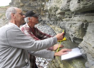
State of the Planet

News from the Columbia Climate School

Earth Sciences104

  • Getting There = 0.5*fun

    Getting There = 0.5*fun

    Hello from the land of the midnight sun! We have just arrived by way of the famous Dalton Highway at Toolik Field Station, a Long Term Ecological Research site of the University of Alaska Fairbanks. We pulled up to the station just in time for dinner, a quick trip to the field station’s wood-fired sauna,…

  • Studying Cutting-Edge Carbon Storage Technologies

    Studying Cutting-Edge Carbon Storage Technologies

    This past June, PhD candidates from Earth Institute’s Lenfest Center for Sustainable Energy Miriam Okun and Yinghuang Ji traveled to Alabama to attend Research Experience in Carbon Sequestration (RECS), an intensive 10-day program hosted by Southern Company and sponsored by the Department of Energy’s National Energy Technology Laboratory.  The program allowed participants to study cutting-edge…

  • When the World Ended in Ice

    When the World Ended in Ice

    A mile or so of glacial ice covering much of North America and plowing down from the north once terminated in the New York metropolitan area, at a front stretching roughly from exit 13 on the New Jersey Turnpike (Rahway), on across southern Staten Island, the Bensonhurst neighborhood of Brooklyn, and northeastward through Long Island. But exactly when that ice started…

  • Mapping Water Circulation Within Cascadia Basin

    Heading west from coastal Oregon we are able to make our initial seismic images beneath the seafloor continuously as we go. Where once our data would have been recorded on magnetic tapes only to be analyzed long after the expedition was over, thanks to the wonders of modern signal processing, we can now make images…

  • X-Ray Vision Beneath the Seafloor

    X-Ray Vision Beneath the Seafloor

    Yesterday we deployed one of the Langseth’s long cables equipped with listening devices and began the second phase of our survey which we have been awaiting with much anticipation.

  • Imaging the Cascadia Subduction Zone

    Imaging the Cascadia Subduction Zone

    In the research expedition now underway, we will investigate the Juan de Fuca plate before it disappears under North America to understand why earthquakes happen where and when they do within the Cascadia subduction zone off the Pacific Northwest. Our ship, the R/V Marcus G. Langseth, is one of 25 research vessels available to U.S.…

  • Investigating Giant, Unseen Landslides

    Investigating Giant, Unseen Landslides

    Steep mountains produce some of the biggest landslides on earth but in such rugged terrain who’s around to notice? These monster back country slides are now gaining attention from far-away scientists, aided by a global network of seismic stations, earth-orbiting satellites and the crowd-sourcing power of the internet.

  • Women Making Waves

    Women Making Waves

    There are quite a few graduate students aboard the Langseth but that isn’t anything out of the ordinary. What is a little unusual is that we’re all women, which is remarkable given the demographics of our field. Read on to find out why we’re proud to be making waves in the South Pacific and in…

  • Press-Ewing Seismograph on Jeopardy!

    Press-Ewing Seismograph on Jeopardy!

    An important piece of earthquake-science history popped up a few weeks ago on Jeopardy!: “The Press-Ewing was an early seismograph, recording waves from these events. If you didn’t know a Press-Ewing from a French press, you were in luck. For $200, all you needed to know to formulate the question is what a seismograph measures.…

Photo of the Earth from space with the text "Lamont at AGU25" on top.

AGU25, the premier Earth and space science conference, takes place December 15-19, 2025 in New Orleans, Louisiana. This year’s theme—Where Science Connects Us—puts in focus how science depends on connection, from the lab to the field to the ballot box. Once again, Lamont-Doherty Earth Observatory and Columbia Climate School scientists, experts, students, and educators are playing an active role, sharing our research and helping shape the future of our planet. #AGU25 Learn More

  • Getting There = 0.5*fun

    Getting There = 0.5*fun

    Hello from the land of the midnight sun! We have just arrived by way of the famous Dalton Highway at Toolik Field Station, a Long Term Ecological Research site of the University of Alaska Fairbanks. We pulled up to the station just in time for dinner, a quick trip to the field station’s wood-fired sauna,…

  • Studying Cutting-Edge Carbon Storage Technologies

    Studying Cutting-Edge Carbon Storage Technologies

    This past June, PhD candidates from Earth Institute’s Lenfest Center for Sustainable Energy Miriam Okun and Yinghuang Ji traveled to Alabama to attend Research Experience in Carbon Sequestration (RECS), an intensive 10-day program hosted by Southern Company and sponsored by the Department of Energy’s National Energy Technology Laboratory.  The program allowed participants to study cutting-edge…

  • When the World Ended in Ice

    When the World Ended in Ice

    A mile or so of glacial ice covering much of North America and plowing down from the north once terminated in the New York metropolitan area, at a front stretching roughly from exit 13 on the New Jersey Turnpike (Rahway), on across southern Staten Island, the Bensonhurst neighborhood of Brooklyn, and northeastward through Long Island. But exactly when that ice started…

  • Mapping Water Circulation Within Cascadia Basin

    Heading west from coastal Oregon we are able to make our initial seismic images beneath the seafloor continuously as we go. Where once our data would have been recorded on magnetic tapes only to be analyzed long after the expedition was over, thanks to the wonders of modern signal processing, we can now make images…

  • X-Ray Vision Beneath the Seafloor

    X-Ray Vision Beneath the Seafloor

    Yesterday we deployed one of the Langseth’s long cables equipped with listening devices and began the second phase of our survey which we have been awaiting with much anticipation.

  • Imaging the Cascadia Subduction Zone

    Imaging the Cascadia Subduction Zone

    In the research expedition now underway, we will investigate the Juan de Fuca plate before it disappears under North America to understand why earthquakes happen where and when they do within the Cascadia subduction zone off the Pacific Northwest. Our ship, the R/V Marcus G. Langseth, is one of 25 research vessels available to U.S.…

  • Investigating Giant, Unseen Landslides

    Investigating Giant, Unseen Landslides

    Steep mountains produce some of the biggest landslides on earth but in such rugged terrain who’s around to notice? These monster back country slides are now gaining attention from far-away scientists, aided by a global network of seismic stations, earth-orbiting satellites and the crowd-sourcing power of the internet.

  • Women Making Waves

    Women Making Waves

    There are quite a few graduate students aboard the Langseth but that isn’t anything out of the ordinary. What is a little unusual is that we’re all women, which is remarkable given the demographics of our field. Read on to find out why we’re proud to be making waves in the South Pacific and in…

  • Press-Ewing Seismograph on Jeopardy!

    Press-Ewing Seismograph on Jeopardy!

    An important piece of earthquake-science history popped up a few weeks ago on Jeopardy!: “The Press-Ewing was an early seismograph, recording waves from these events. If you didn’t know a Press-Ewing from a French press, you were in luck. For $200, all you needed to know to formulate the question is what a seismograph measures.…