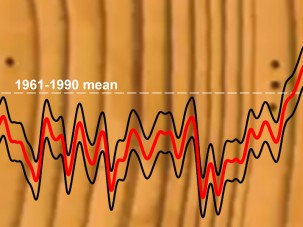
State of the Planet

News from the Columbia Climate School

Earth Sciences66

  • Day 2: What Am I Doing Here, Anyway?

    Day 2: What Am I Doing Here, Anyway?

    The South Pacific Gyre is the most nutrient-poor region in the ocean, and the waters are the clearest in the ocean. The sediments accumulate below the water at rates as low as 0.1 millimeter per thousand years. So, 10 centimeters of seafloor are equivalent to one million years of material deposition in the South Pacific.

  • Detecting Landslides from a Few Seismic Wiggles

    Detecting Landslides from a Few Seismic Wiggles

    Over the last six years, seismologists Göran Ekström and Colin Stark have been perfecting a technique for picking out the seismic signature of large landslides. They just discovered North America’s largest known landslide in many years – 200 million tons of sliding rock in Alaska.

  • Setting Sail? Plan for the Unexpected

    Setting Sail? Plan for the Unexpected

    In the weeks before departing for my first scientific cruise, everyone I knew who had ever been to sea gave me some form of the same advice: Nothing ever works the way you expect it to work at sea.

  • Testing the Speed of Lava: What It Says about Escape Times & Mars

    Testing the Speed of Lava: What It Says about Escape Times & Mars

    Elise Rumpf’s lava flow simulations are yielding new details about the velocity of lava over different surfaces. They may also hold clues about the surfaces of other planets.

  • Catch Up on the Latest in Earth Science with AGU Sessions Live Online

    Catch Up on the Latest in Earth Science with AGU Sessions Live Online

    The American Geophysical Union’s Fall Meeting opens in San Francisco this week. Catch up on your interests through AGU’s On-Demand live stream.

  • Using LiDAR to Shine a Light on Ross Ice Shelf

    Using LiDAR to Shine a Light on Ross Ice Shelf

    LiDar (Light Detection and Ranging) is a remote sensing technique that uses light to develop an elevation image of the surface of the Earth. It is sensitive enough to image small items such as seals lying on the ice surface.

  • Greenland Glaciers Retreating Faster than Any Time in Past 9,500 Years

    Greenland Glaciers Retreating Faster than Any Time in Past 9,500 Years

    A new study uses sediment cores to track the expansion and retreat of glaciers through time, and finds that they are retreating quickly and are more sensitive to temperature change than previously realized.

  • American Geophysical Union 2015: Key Earth Institute Events

    American Geophysical Union 2015: Key Earth Institute Events

    Scientists at Columbia University’s Earth Institute will present important findings at the American Geophysical Union fall 2015 meeting, Dec. 14-18–the world’s largest gathering of earth and space scientists.

  • The Compact Efficiency of New Airborne Science

    The Compact Efficiency of New Airborne Science

    The latest team celebration is around the magnetometer data. Magnetics has evolved quite a bit over the years of geophysical sampling. Lamont scientist Robin Bell recalls when in the 1990s working on a project in West Antarctica that the magnetometer was towed on a winch ~100 meters behind the aircraft – now it is nearly…

Composite banner with modern building at night and portrait of Dean Alexis Abramson that reads "Science for the Planet"

By studying thousands of buildings and analyzing their electricity use, Columbia Climate School Dean Alexis Abramson has been able to uncover ways to significantly cut energy consumption and emissions. Watch the Video: “Engineering a Cooler Future Through Smarter Buildings

  • Day 2: What Am I Doing Here, Anyway?

    Day 2: What Am I Doing Here, Anyway?

    The South Pacific Gyre is the most nutrient-poor region in the ocean, and the waters are the clearest in the ocean. The sediments accumulate below the water at rates as low as 0.1 millimeter per thousand years. So, 10 centimeters of seafloor are equivalent to one million years of material deposition in the South Pacific.

  • Detecting Landslides from a Few Seismic Wiggles

    Detecting Landslides from a Few Seismic Wiggles

    Over the last six years, seismologists Göran Ekström and Colin Stark have been perfecting a technique for picking out the seismic signature of large landslides. They just discovered North America’s largest known landslide in many years – 200 million tons of sliding rock in Alaska.

  • Setting Sail? Plan for the Unexpected

    Setting Sail? Plan for the Unexpected

    In the weeks before departing for my first scientific cruise, everyone I knew who had ever been to sea gave me some form of the same advice: Nothing ever works the way you expect it to work at sea.

  • Testing the Speed of Lava: What It Says about Escape Times & Mars

    Testing the Speed of Lava: What It Says about Escape Times & Mars

    Elise Rumpf’s lava flow simulations are yielding new details about the velocity of lava over different surfaces. They may also hold clues about the surfaces of other planets.

  • Catch Up on the Latest in Earth Science with AGU Sessions Live Online

    Catch Up on the Latest in Earth Science with AGU Sessions Live Online

    The American Geophysical Union’s Fall Meeting opens in San Francisco this week. Catch up on your interests through AGU’s On-Demand live stream.

  • Using LiDAR to Shine a Light on Ross Ice Shelf

    Using LiDAR to Shine a Light on Ross Ice Shelf

    LiDar (Light Detection and Ranging) is a remote sensing technique that uses light to develop an elevation image of the surface of the Earth. It is sensitive enough to image small items such as seals lying on the ice surface.

  • Greenland Glaciers Retreating Faster than Any Time in Past 9,500 Years

    Greenland Glaciers Retreating Faster than Any Time in Past 9,500 Years

    A new study uses sediment cores to track the expansion and retreat of glaciers through time, and finds that they are retreating quickly and are more sensitive to temperature change than previously realized.

  • American Geophysical Union 2015: Key Earth Institute Events

    American Geophysical Union 2015: Key Earth Institute Events

    Scientists at Columbia University’s Earth Institute will present important findings at the American Geophysical Union fall 2015 meeting, Dec. 14-18–the world’s largest gathering of earth and space scientists.

  • The Compact Efficiency of New Airborne Science

    The Compact Efficiency of New Airborne Science

    The latest team celebration is around the magnetometer data. Magnetics has evolved quite a bit over the years of geophysical sampling. Lamont scientist Robin Bell recalls when in the 1990s working on a project in West Antarctica that the magnetometer was towed on a winch ~100 meters behind the aircraft – now it is nearly…