CIESIN13
-
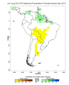
Climate Forecasts: A Vital Tool for Policymakers
Focusing on near-term probabilities can also aid in decreasing vulnerability to future climate uncertainties.
-

Mapping Flood Exposure in Southwest Haiti
Mapping flood exposure in Haiti is part of ongoing research at CIESIN on environmental risks and integrated development there.
-

Bright Lights, Big City?
Researchers using nighttime lights data to ask questions about economic development in sub-Saharan Africa have findings counter to expectation.
-

A Road Map Toward Better Understanding of Global Environmental Change
The Social Process Diagram published in 1992 was an attempt to map out the key systems and interactions among systems that were seen as underpinning the human drivers of global environmental change.
-

Overcoming Challenges to Local Development in Haiti
Haiti Dialogue Series: Should funds be more effectively channeled through the Haitian government, a decentralized finance program could help streamline financing and reinforce local government planning efforts. As part of the Haiti Research and Policy Program dialogue series, Tatiana Wah was joined by Leslie Pean to discuss possible approaches to achieving the call for decentralization…
-

Migration in Risk-Prone Areas
Access to data that lets us analyze global migration patterns is critical to climate change adaptation planning, among other applications.
-

The Impact of Sea Level Rise on Coastal Wetlands
An analysis of coastal wetlands loss from sea level rise that was conducted for the Ramsar Convention’s Scientific and Technical Review Panel provides estimates of wetland losses as a basis for identifying potential adaptation measures.
-

New Understanding of Soil Quality throughout Africa
A new interactive mapping tool lets users visualize a broad range of soil data for the continent of Africa.
-

Sandy’s Surge Affected More Than 1.4 Million in 11 States
Based on a model used by the U.S. Federal Emergency Management Agency (FEMA), the map shows coastal areas likely to have been inundated by the storm surge resulting from Hurricane Sandy, in relationship to residential population.


Columbia Climate School is bringing bold ideas, leading experts, and groundbreaking research to Climate Week NYC. Explore our events, stories, and updates as we help shape the conversation on climate action across New York City.
