CIESIN6
-
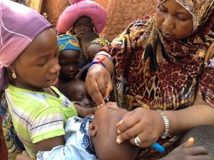
Technology Behind GRID3 Program Helps Eradicate Wild Polio in Nigeria
Geospatial data holds great potential to improve health, food security, and educational opportunities in developing countries.
-

How Religion Influences Our Relationship With the Environment
A new study looks at the links between religion and attitudes toward the environment.
-

Our Biggest, Best Event of the Year is Going Virtual
Lamont Open House at Home is four days of exciting and informative virtual earth science activities for children, families, educators, and science enthusiasts of all ages.
-

Seeking Intern to Help Investigate Global Flood Risk
The project objective is to create a global flood hazard risk layer, to be included in a flood risk model, that incorporates exposure and social vulnerability that will be capable of capturing climate changes.
-

EI LIVE K12: RSVP for Our Upcoming May Sessions
Learn how to design your own microbe, decode Python script, and much more in these live sessions taught by Earth Institute experts.
-

Global COVID-19 Map Viewer Shows Case Data, Age/Sex Features of At-Risk Populations
A new tool provides data that can help identify populations most at risk from coronavirus, around the world and down to the U.S. county level.
-

Earth Institute Goes Live in Video Series for K12 Students and Educators
Through ‘EI Live,’ experts from across the Earth Institute will share their work through live lectures, interactive activities, and demos. The series launches April 6.
-

GRID3 Project Aims to Put Everyone on the Map
Detailed population data from the project is helping to protect against disease and plan for new schools in low- and middle-income countries. It may also enhance food security and disaster response.
-

Rising Seas Threaten Low-Lying Coastal Cities, 10% of World Population
In a new report, CIESIN researchers help to identify urban populations at risk from sea level rise. Their updated data set is meant to inform adaptation strategies.


You Asked invites you to share your most pressing questions about climate, science, and sustainability. Lamont-Doherty Earth Observatory and Columbia Climate School experts will respond with clear, evidence-based answers. Pose your questions and story ideas!
