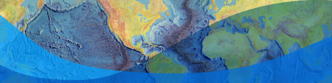
State of the Planet

News from the Columbia Climate School

Tag: mapping

  • Data Dive: Heat Mapping New York City and Environmental Justice

    Data Dive: Heat Mapping New York City and Environmental Justice

    For researcher Liv Yoon, creating a high-resolution heat map of NYC is just the first step in transforming marginalized communities.

  • Life Aboard a Research Cruise: 24-Hour Workdays, Amazing Discoveries

    Life Aboard a Research Cruise: 24-Hour Workdays, Amazing Discoveries

    When scientists say “research cruise,” they aren’t talking about sunny afternoons of shuffleboard and margaritas on deck. Life aboard a research vessel means tight spaces, few amenities, and long workdays.

  • Going Deep for Science

    Going Deep for Science

    Bridgit Boulahanis, a marine geophysics graduate student at Lamont-Doherty Earth Observatory, prepares to head out on her first research cruise exploring the seafloor with underwater vehicles.

  • The Floor of the Ocean Comes into Better Focus

    The Floor of the Ocean Comes into Better Focus

    The bottom of the ocean just keeps getting better. Or at least more interesting to look at.

  • A Simple Question, Unexpected Applications – and an Award

    A Simple Question, Unexpected Applications – and an Award

    Even the simplest research questions can lead to far-reaching public benefits. Consider Chris Small and Joel Cohen’s study of global population by altitude, being honored this week at the Library of Congress.

  • Mapping Land Claimed by Sea Level Rise

    Mapping Land Claimed by Sea Level Rise

    Understanding how coastal areas changed as the ocean rose in the past could help communities protect themselves from storm surge flooding in the future as the oceans warm and sea levels rise.

  • Remote Data Team Helped Put Haiti Back on the Map

    Remote Data Team Helped Put Haiti Back on the Map

    Before the Haiti earthquake, few publicly available maps of the country existed. When the earthquake hit in 2010, some of the little data that existed was destroyed. Then a team at Tufts University went into action, and from afar, helped build updated maps of roads and earthquake damage to help humanitarian organizations deal with the…

  • Mobile Maps Help Haitians Locate Government Offices

    Mobile Maps Help Haitians Locate Government Offices

    Until last month, Haitians had no way to search online to find the location of government offices. Now, thanks to a collaboration between the Earth Institute and Haiti’s government, there’s a registry of every government office accessible online and on mobile devices.

  • Migration in Risk-Prone Areas

    Migration in Risk-Prone Areas

    Access to data that lets us analyze global migration patterns is critical to climate change adaptation planning, among other applications.