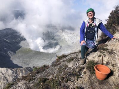
In our quest to unravel the physical and chemical processes controlling volcanic eruptions, we headed to South America a few weeks ago and the mountains of Chile. Chile has more than 100 volcanoes, making it a paradise for volcanologists. The volcanoes present a natural hazard to communities (the eruption of Calbuco in 2015 and Chaitén in 2008, for example). At the same time, they are responsible for the extensive deposits of ores and Chile’s thriving mining-based economy.
With funding and support from the Columbia University Global Center in Santiago, Prof. Philipp Ruprecht organized an international workshop that brought together 18 U.S. and Chilean scientists and students interested in volcanoes. We started with a day of presentations and introductions in Santiago, then headed south to the town of Talca. It’s been a regional center for centuries, but it has mostly new buildings because the town has been repeatedly damaged by earthquakes, as recently as 2010.
A short bus ride from Talca brought us to Laguna Invernada, a protected biological reserve at the foot of Cerro Azul, a large volcano. We observed how the laguna sits at the contact between an ancient layer of sediments and a large intrusive pluton—magma that cooled just below the surface without erupting. This contact is the pathway for mineral deposits being mined in the region (mostly iron, copper and gold), as well as for volcanism.

Our first day in the field took us up a slope covered in ash and tephra from two cinder cones. Climbing on this kind of terrain is an exercise in patience, with a step back for every two steps forward. In addition, we were very nervous during the climb—the horses that were supposed to come get our gear did not show up! But after a few hours they arrived—phew!
The next day took us over a mountain pass, and from it we could finally see the main research target for our trip: the cone of Volcán Quizapu, the massive lava flows that erupted from Quizapu in 1846, and the thick layer of white pumice from Quizapu’s explosive eruption of 1932. Also in view was the neighboring Volcán Descabezado (“the beheaded”) Grande and the triplet of cones of La Roselana Sur, Centro and Norte.


We spent the five days exploring the lava flows and cones. Our goal was to examine the details of the lava flows, which hold clues about how volcanic eruptions begin and evolve and what may set the style of an eruption into benign lava flows versus a large explosion. We collected more than 60 samples of lavas that we’ll be analyzing over the coming months. Our goal is to reveal any changes in the chemical composition and physical state (fraction of bubbles and crystals) of the lava as it flows away from the vent.
We accompanied our sampling on the ground with “sampling” from the air: Our drone collected thousands of aerial photographs of the lava flows, which will help us build a high-resolution topographic map for the flows and estimate their volume and shape precisely. Click here to watch a video of the area we filmed with the drone.

After another difficult climb up a slippery and soft slope, we got to peek into the crater of Quizapu from the rim (photo at top). Laying flat on our bellies to manage against the strong winds, we marveled at the complex layers and structures, evidence to the complex chemical and physical processes that shaped it.
Our last day provided a unique experience—to leave the field area and reach the nearest village of Parque Inglés, we rode horses for five hours! And these are not your average horses—these horses can handle the roughest terrain, rocky lavas and soft pumice and ice-cold streams. What a remarkable way to end a fascinating field trip!
The group along for the field trip included, from Lamont and Columbia: Philipp Ruprecht, Einat Lev, Elise Rumpf, Megan Newcomb, Dan Rasmussen, Lucy Tweed, Anna Barth and Kevin Krajick; from the University of Hawaii: Julia Hammer and Emily First; from the University of Michigan: Adam Simons; from the University of Chile, Santiago: Camila Pineda, Rayen Gho, Maria Contreras and Daniela Astaburuaga; and from Universidad of de Concepción: Pablo Salas, Francisco Garcia and Paulina Henry.
Einat Lev is an assistant research professor at Lamont-Doherty Earth Observatory whose work focuses on geodynamics and physical volcanology. Read her post from September on using drones to map lava flows in Iceland.


Is it technically & economically feasible to perform core sampling on a pumice flow to determine consistency of light gray well foamed pumice to various depths? The area in question are pumice domes in Mono County California. Thanks in advance for your insight.
Steve —
I believe it should be possible to drill into these flows — such core samples will give important information about how the lava cooled and flowed. But first we should look at cores that are already exposed, for example by rivers that cut through old flows. This has been done in other places.
Awe inspiring. The power and grandeur of Mother Earth. Are core samples an option or of potential value? As an archaeologist, I want to “see” what lies beneath.