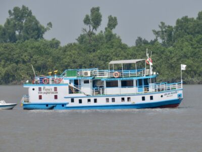
When we finally got to Khulna, the second largest city in Bangladesh, Bachchu, who organized the boat, met us and led us down country roads to where we met our boat, the M/V Kokilmoni, our home for the next few days. It is very large for the four of us and Bacchu, but faster and safer when there is still a risk of cyclones, as hurricanes are called in the Indian Ocean. Luckily the forecast is for 10 days of clear sky and 90° weather. When we got to the dock (ghat in Bangla), a crew from the ship was there with the launch to ferry us and our loads of equipment to the ship. After stowing it all away, dinner at a reasonable time.

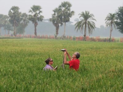
The Kokilmoni sailed down the channel to near the location we will install our GPS on Polder 32. Back in the 1960s, Bangladesh (then East Pakistan) constructed embankments or polders around much of the low-lying coastal region. The region is crisscrossed by numerous interconnecting rivers separating the land into islands. The government built embankments around many of them to protect them from flooding. However, they also prevented the sedimentation necessary to maintain the land. Without either flooding or sediment, the sediments compacted and the land subsided so that it is now 3-4 feet below the land outside the polders that continue to get sedimentation. This set the stage for Cyclone Aila in 2009 and the storm breached the embankment in multiple places. Initial repairs did not hold and the island was submerged for most of two years. What should be done for the poldered areas in the face of continued sea level rise is a major question. Our GPS will provide much needed data on the rate of subsidence.

Polder 32 is a main focus site of a large project funded by ONR, the Office of Naval Research. This project looks at not just the physical side of the balance of sea level rise, subsidence and sedimentation, but also the local population’s interaction with the environment and their potential response to disasters, such as temporary or permanent migration. In fact, social scientists make up the most of the project. The lead institution of this project is Vanderbilt University and there is a group of them here at Polder 32, too. Unfortunately they are on the opposite side of the island, so we were unable to meet up. Neither of us had the few hours to spare to sail over to the other.

Anyway, we again prepared the GPS equipment into the night, then work up early to install the GPS. At least on the Kokilmoni, there was tea and cookies to help us cope with the 6AM start. Plus we had a crew to help carry everything to the site, including a very heavy diesel generator to provide power for the drill. They dropped us off at a dock connected by a bamboo bridge to shore, then moved to a place where they could offload the equipment. They insisted on carrying everything for the 1-kilometer walk to the elementary school we will use.

In May, Dhiman and Steve did an elevation survey of the entire polder and set up a reference station at the school. Then they left the GPS there to get a head start on collecting data with a temporary “campaign” set up. When we got to the roof, we saw the installed antenna, but the GPS had failed. The flimsy portable solar panel could not hold up to the monsoon. Still the data for May and June it go will be valuable and the antenna is already installed. After a discussion with the headmaster about where to put the receiver, we put it in their computer room (solar powered). Just outside is a statue of the Hindu goddess of education as this village is almost entirely Hindu.

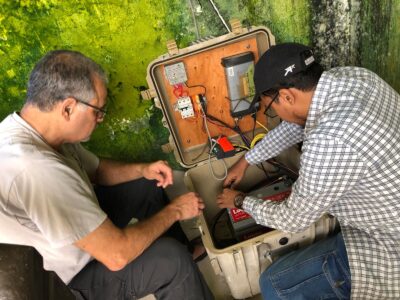
We went to work, with our now experienced team splitting up the tasks, with Sarah doing the most technical parts. I drilled the holes in the roof and bolted the solar panel down and secured the antenna cable to the roof. When it was done, we headed back to the ship to head to Hiron Point in the Sundarbans, the world’s largest mangrove forest and nature preserve that is home to 350-400 tigers. And we finally got to eat a lunch at a reasonable time. As a Sundarban tourist boat, the Kokilmoni has very good food.


Dear Mr Zakir
I need to get an image file/gis based map of the polder locations on coastal areas. Can you please inform me where from I can get those GIS based map or soft copy of polders locations.
Thanks
Manir
Dear Miss Ruma
I have completed my dissertation on Polder in Bangladesh. To inform you i would like to say that polders in Bangladesh were built during the Pakistani rule in the early sixties.
If any query pls don’t hesitate to send me a mail.
Zakir
B.Sc. and M.Sc. from BUET.
Dear,
This article is very informative and seems to be useful for my Undergraduate Thesis.
I have a request. Can you please tell me whom I can contact to know the timeline of conctruction of Polders in the coastal regions of Bangladesh?
I have written email to Bangladesh Water Development Board, and probably will phone the World Bank, Bangladesh Office as they are said to fund and conduct the polder projects. Is it a good idea?
Thanks.
Ruma