CIESIN10
-
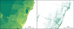
Working with Facebook to Create Better Population Maps
Knowing how settlements are distributed across the landscape—e.g., in clusters, along roads or waterways, or scattered widely—has important implications for designing infrastructure, improving access, and promoting sustainability.
-

How Well is the World Protecting Ecosystems and Human Health?
The new global environmental report card is out. The 2016 Environmental Performance Index graded 180 countries on how well they are protecting human health and their ecosystems. While the world is making progress in some areas, it is seriously falling behind in others.
-

The Changing Face of Air Quality
Looking at regional differences in PM2.5 concentrations gives us a sense of the changing face of air quality throughout the world.
-

Certificate Program to Focus on Environment and Security
A new professional certificate program at Columbia University will address the linkages between environment and security, aimed at practitioners with responsibility for providing assessments and warnings regarding environment-security risks or for designing programs to manage such risks.
-

Mapping Tool Lets Users Pinpoint Hazards Data
The SEDAC Hazards Mapper is designed for disaster risk managers, humanitarian response organizations, public health professionals, journalists and others needing a quick assessment of the potential dangers posed by a major hazardous event or developing emergency.
-

Make Yourself Count: Sandy Hook ‘BioBlitz’
Amateur naturalists will gather this weekend at the Sandy Hook, N.J., unit of the Gateway National Recreation Area to count species of plants and animals.
-

State of the Map 2015 in NYC
OpenStreetMap has had impressive growth in coverage and detail in the decade since its launch, and is increasingly being seen as an authoritative data source, much as Wikipedia has rivaled traditional encyclopedias for content and currency.
-

Critical Role for Geospatial Data in Advancing Sustainable Development Goals
To ensure no one is left behind by the next generation of global development goals, a comprehensive mix of robust data is needed to measure progress and guide investments. A recent report coordinated by the Sustainable Development Solutions Network estimates the world will need to spend roughly $1 billion a year to sustain and enhance…
-

Fragile States Use Geospatial Data and Maps to Better Manage Natural Resources
Some of the world’s poorest nations have an abundance of natural resources, but also have suffered under recent conflicts. Learning how to manage these resources strategically and sustainably can help accelerate growth and development. A new web-based mapping tool may be able to help them do that.


By studying thousands of buildings and analyzing their electricity use, Columbia Climate School Dean Alexis Abramson has been able to uncover ways to significantly cut energy consumption and emissions. Watch the Video: “Engineering a Cooler Future Through Smarter Buildings“
