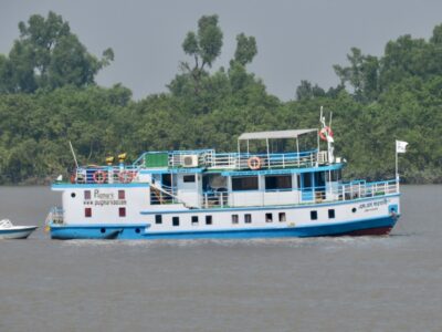
We left Hiron Point with the high tide and sailed through small channels of the Sundarbans Mangrove Forest. As a tidal marsh, the Sundarbans is crisscrossed by channels with sizes that range from 10 km across to less than a foot. The tides rise and fall periodically inundating all of the land. Mangroves are trees that are adapted to living in brackish water. Different tree species are found in different parts of the Sundarbans, adapted to different levels of saltiness.
We arrived at Kotka in the afternoon. Most of the group went on a forest walk with Tanzeel, our guide. A smaller group of us split off to visit thee remains of 300-year old salt kilns. We passed Chital deer and a wild boar on the way. A stag was silhouetted at the coast before it ran off. The

people that built the kilns used to allow seawater to flow into evaporation pans at Spring high tide. Before the next Spring tide they would bake the concentrated brine in clay pots to produce salt. The kilns are surrounded by innumerable potsherds, and quite a few intact clay pots. It is thought that the operation was suddenly destroyed, abandoned and buried, perhaps by a 1699 cyclone that killed 50,000 people. Recent erosion, include the destruction by Cyclone Sidr in 2007 have unearthed them.
Since the age of the kilns is known, it is a good site for Liz to use OSL dating to determine the sedimentation rate. We drilled several auger hole to determine the stratigraphy, the deepest one was 5.8 meters. Liz drilled assisted by two crew from

the Kokilmoni while I took notes and photos. The kiln site is now in the intertidal zone – exposed at low tide and covered at high tide. This means that they have subsided since they were last used. The rate is estimated as 4.1 mm/yr by a German group that worked here. We completed 3 holes, but ran out of daylight before we could take the OSL samples. We returned to the ship, walking past buildings destroyed by Sidr with our larger group who ended their forest walk at the kiln site.
We returned at dawn the next morning – with a guard to protect against tigers – while the remainder of the group went on a silent ride up a tidal creek. We collected 3 OSL samples from different depths, the last one completed as the rising tide reached over our knees. Whenever the

sampler was removed from the hole, one of us had to keep our hand in the hole, usually Matt, so we could find it again. Happy with our successful sampling, we returned to the ship for breakfast.
Back with the others, we set out for a forest walk to Kotka Beach. Climbing an observation tower, we got an overview of the region. There are old shoreline deposits here that are above the high water level. These sediments provide evidence of the seaward progradation of delta. As a result there is a meadow and many non-mangrove species as the area doesn’t regularly flood. This attracts a lot of deer and, as a result, tigers. However, we only deer. We also walked through the muddy mangrove forest and finally emerged at Kotka Beach where we went swimming in the Bay

of Bengal. We continued along the beach for a few kilometers passing hordes of scurrying crabs. Finally, we rejoined the Kokilmoni for a late lunch.
In this area, plans always have to be adjusted according to the tides and weather. As a result, we switched our visit to Bird and Egg Islands to later in the afternoon instead of the following morning. These two islands emerged from the sea about 20-25 years ago and have grown and merged. In answer to the age old question, the Egg came first. While a few people skipped the walk after the morning’s trek, most of us went along. It is a great place to see the biological succession that develops on a new island. The coast is bare sand with the high water mark littered with plant debris. Beyond the wind-blown coastal dunes, grasses

have taken hold. Then tall grasses and a scattering of shrubs and then trees in a muddy salt marsh. Finally in the distance is a full-fledged mangrove forest. We saw tracks and spoor of deer and monkeys, but as of yet there are no tigers on the island.
An unsuspected bonus was a tidal channel near the beach. Here at small scale, we could see all the features of river systems that we discussed in class: cut banks and point bars, meanders and avulsions, small deltas and chars. All at a scale that brought the geology to life for the students far better than any lecture or photos. It was a long and very successful day in the Sundarbans.


