Earthquakes16
-
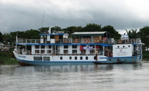
Joining the Kokilmoni
After a great field season last winter, we had an extraordinary opportunity this fall, a research cruise on the Bangladeshi rivers collecting geophysical data. We are using the same technique that Lamont uses on its ship, the R/V Marcus Langseth, but a mini version. The basic idea is to use sound waves from bursts of…
-

Magnitude 5.8 Quake Rattles East Coast
The magnitude 5.8 earthquake that shook central Virginia on Tuesday afternoon is one of the biggest earthquakes to hit the East Coast since 1897, and was comparable in strength to a quake on the New York-Canadian border in 1944, according to the U.S. Geological Survey. It was centered near Mineral, Va., about 38 miles northwest…
-

Returning From Sea to Dutch Harbor
At 6:30 am on August 5, the R/V Langseth pulled into port in Dutch Harbor, marking the end of our very successful research cruise. Our steam into port from our study area involved a trip through Unimak pass and beautiful views of Aleutian volcanoes, including majestic Shishaldin. Many things are required to make a research…
-

Swimming in Data Offshore Alaska
Although we still have ~3 days of data collection aboard the R/V Langseth to go before we pull in our equipment and head for port, we are already drowning in beautiful seismic data. Following each pulse from the air gun array, the two 8-km-long streamers listen for returning sound waves for 22 seconds. This is…
-

Boring Days at Sea are a Blessing
For the last nine days, we have been underway acquiring seismic reflection data to study a plate tectonic boundary offshore Alaska with the R/V Marcus G. Langseth. Now that the initial excitement of deploying all of our seismic gear and watching the first sound waves arrive on our two 8-km-long streamers has faded, we have…
-

Undersea Clues to Haiti’s Earthquake History
For all of its violent destruction, the earthquake that struck Haiti on Jan. 12, 2010, hardly scratched the surface of the island. But scientists now say they have found some of the best clues to understanding the quake under water.
-

Collecting Data Offshore Alaska, But Just Barely
One of the core objectives of our project is to image the part of the plate tectonic boundary that locks up and then ruptures to produce great earthquakes. To examine deep parts of the interface between the Pacific plate and the North American plate in the Aleutian subduction zone, we need to go as close…
-

Unspooling Miles of Seismic Streamer Near the Shumagin Islands
On July 11, we marked the successful completion of the first phase of our project and embarked on the second. Part 1 involved deploying ocean bottom seismometers and recording air-gun-generated sound waves. We successfully retrieved all of the OBS’s, and the data that they recorded look very exciting at first blush (and contain some surprises!).
-

Lurking Under Bangladesh: The Next Great Earthquake?
Beneath Bangladesh: The Next Great Earthquake? from Earth Institute on Vimeo. After the recent great quakes that have swept away entire coastlines and cities in Japan, Haiti and Sumatra, scientists are now looking hard at the nation that may suffer the gravest threat of all: Bangladesh. A new documentary from the Earth Institute follows seismologists as they trace signs of…


The first Earth Day in 1970 ignited a movement to stop polluting our planet. Today, our scientists and experts are tackling the most pressing challenges to achieve real-world impact. This Earth Day, join us in our commitment to realizing a just and sustainable future for our planet. Visit our Earth Day website for ideas, resources, and inspiration.
