What do the economy and tropical ocean temperatures have in common? They’re both exhibiting patterns very similar to 2008. At the International Research Institute for Climate and Society’s monthly climate briefing, chief forecaster Tony Barnston focused more on the latter. He laid out the past and the present and what clues they provide about the future.
The Past
Starting in November 2010, La Niña, an anomalous cooling of waters in the eastern equatorial Pacific, wreaked havoc with weather around the globe. It was a near record event by some measures. By May 2011, though, the associated cool ocean temperatures dissipated, marking the end of the event. Since then, ocean surface temperatures have remained near normal. And for the past few months, forecasters have been predicting things to remain that way for the rest of the year.
That makes sense. After a La Niña, conditions usual hang around normal or flip to El Niño in the tropical Pacific. Of course, the expected doesn’t always happen.
In the winter of 2007-08, a fairly strong La Niña developed. It subsided by May of 2008, and at that point, forecasters were fairly certain neutral conditions would reign for the rest of the year. Yet in December 2008, ocean temperatures suddenly dipped, throwing the eastern Pacific back into La Niña conditions.
The second La Niña wasn’t as strong as the first that year. Still, regions normally affected by La Niña felt some impacts such as heavy rains in Australia in November and December and above-normal snowfall in the Pacific Northwest throughout the winter. The event ultimately held on for five months before ocean temperatures returned to normal in April 2009.
The Present

The graph to the right shows how the most recent La Niña stacks up against others. While its possible ocean temperatures could remain near their current levels as they did after the 1989-90 La Niña, this year has one key factor upping the likelihood of a second La Niña à la 2008-09: a large pool of unusually cold water sitting 100 meters below the surface.
One hundred meters might sound like it’s too far below the surface to matter much to what’s going on above. However, the much warmer water that usually acts as a cap is missing in action. That means it possible that the cold water could reach the surface. If it does, it would likely mean the return of La Niña conditions.
Of course it could also dissipate below the surface, meaning near-normal surface temperatures, and thus neutral conditions, would prevail. “The biggest mystery is what it will do,” said Barnston. “We’ll see how this plays out in the coming weeks.”
The Future

On August 4, the Climate Prediction Center (CPC) issued a La Niña Watch. It explains that while neutral conditions are most likely through the fall, the chances of La Niña conditions increase through the early winter until they’re even with neutral conditions.
IRI’s forecast is slightly more conservative. It shows that from November to January, the likelihood of La Niña developing is 44%, while neutral conditions are slightly more likely at 54% (El Niño has a 2% probability of occurring, but as the great Justin Bieber says, never say never).
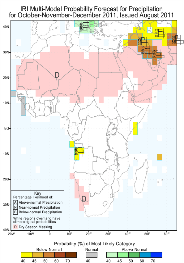
Should it occur, a double dip La Niña could have implications beyond ski areas in the Pacific Northwest. Of particular concern is what it could mean for the current humanitarian crisis in the Horn of Africa. That’s because the region’s short rain season, which runs from October to December, is negatively influenced by La Niña.
Those rains are very important to agriculturists including groups IRI works with in conjunction with the Research Program on Climate Change, Agriculture and Food Security. If they were to fail, it would be the third failed rainy season in a row. The resulting weak harvest could further aggravate food insecurity in the region.
The most recent climate forecast from IRI shows a slight tilt for some of the region to experience below normal rainfall. As ocean temperatures in the Pacific continue to evolve, so, too, will the forecast. Visit IRI’s forecast page for the most recent climate forecast. And for more on East Africa, visit IRI’s Vimeo page to hear experts weigh in on the role of drought in famine and the tools being used to monitor it.
For more updates from IRI, follow us on Twitter.


[…] it’s nearly official: La Niña is making her second appearance this year. After a few months’ hiatus this summer, ocean […]