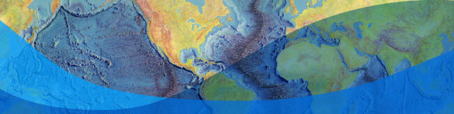
State of the Planet

News from the Columbia Climate School

Tag: GIS

  • Students Take the Driver’s Seat in Drone-Enabled Geospatial Data Analysis

    Students Take the Driver’s Seat in Drone-Enabled Geospatial Data Analysis

    Columbia College students pilot drones to enhance the power of their geospatial data collection.

  • Fire and Ice: New Database Maps and Classifies the Dangers of Glacierized Volcanoes

    Fire and Ice: New Database Maps and Classifies the Dangers of Glacierized Volcanoes

    A new study maps the world’s glacierized volcanoes and could help predict the dangers of future glaciovolcanism.

  • CIESIN seeks GIS Interns

    CIESIN seeks GIS Interns

    Detail-oriented students interested in GIS data exploration, analysis, and documentation can apply by September 24.

  • Students Practice GIS and Remote-Sensing Field Work in Black Rock Forest

    Students Practice GIS and Remote-Sensing Field Work in Black Rock Forest

    When it comes to learning about data collection techniques, there is no substitute for field work. In October, three Columbia classes embarked on a field trip to the Black Rock Forest in Cornwall, New York, to get some hands-on experience.

  • A Life Well Mapped

    A Life Well Mapped

    Mark Becker believed in the power of geospatial data and analysis to motivate our stewardship of the environment and guide development of sustainable approaches that balance human and environmental needs.

  • In Your Own Backyard: Mapping Communities Near Superfund Sites

    In Your Own Backyard: Mapping Communities Near Superfund Sites

    The NPL Superfund Footprint Mapper is an interactive, online mapping application—a clickable map—that lets users visualize a rich variety of population and environment characteristics of areas in the vicinity of Superfund sites.

  • Track the Number of People in Irene’s Path

    Track the Number of People in Irene’s Path

    As Hurricane Irene barrels up the East Coast, the number of people affected is rising. Based on calculations at 2 pm on Saturday, more than 47 million people were within 100 miles of the storm track; and nearly 69 million within 200 miles, according to Columbia’s Center for International Earth Science Information Network(CIESIN). Visit CIESIN’s…

  • Updated Map Viewer Enables Visualization of Socioeconomic and Earth Science Data

    Updated Map Viewer Enables Visualization of Socioeconomic and Earth Science Data

    Terra Viva SEDAC Viewer, a map viewer and standalone software application, has been updated for 2011 with the addition of several new SEDAC data sets, including climate change scenario data and indicator collections with hundreds of variables. Terra Viva contains map data and GIS functions in one package. An excellent tool for educators, as well…

Science for the Planet: In these short video explainers, discover how scientists and scholars across the Columbia Climate School are working to understand the effects of climate change and help solve the crisis.
  • Students Take the Driver’s Seat in Drone-Enabled Geospatial Data Analysis

    Students Take the Driver’s Seat in Drone-Enabled Geospatial Data Analysis

    Columbia College students pilot drones to enhance the power of their geospatial data collection.

  • Fire and Ice: New Database Maps and Classifies the Dangers of Glacierized Volcanoes

    Fire and Ice: New Database Maps and Classifies the Dangers of Glacierized Volcanoes

    A new study maps the world’s glacierized volcanoes and could help predict the dangers of future glaciovolcanism.

  • CIESIN seeks GIS Interns

    CIESIN seeks GIS Interns

    Detail-oriented students interested in GIS data exploration, analysis, and documentation can apply by September 24.

  • Students Practice GIS and Remote-Sensing Field Work in Black Rock Forest

    Students Practice GIS and Remote-Sensing Field Work in Black Rock Forest

    When it comes to learning about data collection techniques, there is no substitute for field work. In October, three Columbia classes embarked on a field trip to the Black Rock Forest in Cornwall, New York, to get some hands-on experience.

  • A Life Well Mapped

    A Life Well Mapped

    Mark Becker believed in the power of geospatial data and analysis to motivate our stewardship of the environment and guide development of sustainable approaches that balance human and environmental needs.

  • In Your Own Backyard: Mapping Communities Near Superfund Sites

    In Your Own Backyard: Mapping Communities Near Superfund Sites

    The NPL Superfund Footprint Mapper is an interactive, online mapping application—a clickable map—that lets users visualize a rich variety of population and environment characteristics of areas in the vicinity of Superfund sites.

  • Track the Number of People in Irene’s Path

    Track the Number of People in Irene’s Path

    As Hurricane Irene barrels up the East Coast, the number of people affected is rising. Based on calculations at 2 pm on Saturday, more than 47 million people were within 100 miles of the storm track; and nearly 69 million within 200 miles, according to Columbia’s Center for International Earth Science Information Network(CIESIN). Visit CIESIN’s…

  • Updated Map Viewer Enables Visualization of Socioeconomic and Earth Science Data

    Updated Map Viewer Enables Visualization of Socioeconomic and Earth Science Data

    Terra Viva SEDAC Viewer, a map viewer and standalone software application, has been updated for 2011 with the addition of several new SEDAC data sets, including climate change scenario data and indicator collections with hundreds of variables. Terra Viva contains map data and GIS functions in one package. An excellent tool for educators, as well…