State of the Planet

News from the Columbia Climate School

Geohazards in Bangladesh3
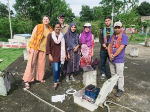
  • Struggling With Towed Equipment, Repairing GPS, and Home

    Struggling With Towed Equipment, Repairing GPS, and Home

    We switched to a towed electromagnetic system to image the fresh and saline groundwater in Bangladesh, and ran into a variety of problems, including high winds, strong currents and running aground.

  • Continuing the Survey: Watermelon and Winds

    Continuing the Survey: Watermelon and Winds

    Continuing our electromagnetic survey of fresh and saline groundwater, we saw the landscape change from lush watermelon fields to fallow rice fields as the salinity increased towards the sea.

  • Barisal and the Eastern Channel

    Barisal and the Eastern Channel

    We are continuing our measurements of fresh and saline groundwater in Bangladesh using electromagnetic instruments. We finished our first set of measurements and have now shifted farther east near Barisal where groundwater is fresher.

  • Deploying in the Mangrove Forest

    Deploying in the Mangrove Forest

    We continued our electromagnetic expedition to image fresh and saline groundwater into the Sundarbans Mangrove Forest, the world’s largest. While guards protected us from tigers, it was a wild boar that dug up some of our equipment.

  • Sailing Around the Bangladesh Coastal Zone

    Sailing Around the Bangladesh Coastal Zone

    I am back in Bangladesh to explore the distribution of fresh and saline groundwater in the coastal zone, needed for drinking in the dry season.

  • Into the Sundarban Mangrove Forest and Back

    Into the Sundarban Mangrove Forest and Back

    For the last week of our trip, we traveled by boat to reach the sites where we are measuring subsidence in the Sundarban Mangrove Forest and nearby embanked islands.

  • From Barisal to Khulna

    From Barisal to Khulna

    We continued to service our GNSS and RSET-MH equipment measuring land subsidence in coastal Bangladesh. Long distances, poor roads and slow ferries made for very long days, but we were able to complete the work at the sites.

  • Dhaka and Beyond

    Dhaka and Beyond

    After a week of meetings and a wedding in Dhaka, we headed back to the field to service equipment measuring land subsidence in Bangladesh.

  • Back to Bangladesh at Last

    Back to Bangladesh at Last

    I am finally back in Bangladesh after a pandemic hiatus. I need to repair precision GPSs that failed over the last few years. They are measuring tectonic movements for earthquake hazard and land subsidence, which exacerbates sea level rise.

Earth Month Graphic Collage: "Our Power, Our Planet - April 2025"

The first Earth Day in 1970 ignited a movement to stop polluting our planet. This Earth Month, join us in our commitment to realizing a just and sustainable future for our planet. Visit our Earth Day website for ideas, resources, and inspiration.

  • Struggling With Towed Equipment, Repairing GPS, and Home

    Struggling With Towed Equipment, Repairing GPS, and Home

    We switched to a towed electromagnetic system to image the fresh and saline groundwater in Bangladesh, and ran into a variety of problems, including high winds, strong currents and running aground.

  • Continuing the Survey: Watermelon and Winds

    Continuing the Survey: Watermelon and Winds

    Continuing our electromagnetic survey of fresh and saline groundwater, we saw the landscape change from lush watermelon fields to fallow rice fields as the salinity increased towards the sea.

  • Barisal and the Eastern Channel

    Barisal and the Eastern Channel

    We are continuing our measurements of fresh and saline groundwater in Bangladesh using electromagnetic instruments. We finished our first set of measurements and have now shifted farther east near Barisal where groundwater is fresher.

  • Deploying in the Mangrove Forest

    Deploying in the Mangrove Forest

    We continued our electromagnetic expedition to image fresh and saline groundwater into the Sundarbans Mangrove Forest, the world’s largest. While guards protected us from tigers, it was a wild boar that dug up some of our equipment.

  • Sailing Around the Bangladesh Coastal Zone

    Sailing Around the Bangladesh Coastal Zone

    I am back in Bangladesh to explore the distribution of fresh and saline groundwater in the coastal zone, needed for drinking in the dry season.

  • Into the Sundarban Mangrove Forest and Back

    Into the Sundarban Mangrove Forest and Back

    For the last week of our trip, we traveled by boat to reach the sites where we are measuring subsidence in the Sundarban Mangrove Forest and nearby embanked islands.

  • From Barisal to Khulna

    From Barisal to Khulna

    We continued to service our GNSS and RSET-MH equipment measuring land subsidence in coastal Bangladesh. Long distances, poor roads and slow ferries made for very long days, but we were able to complete the work at the sites.

  • Dhaka and Beyond

    Dhaka and Beyond

    After a week of meetings and a wedding in Dhaka, we headed back to the field to service equipment measuring land subsidence in Bangladesh.

  • Back to Bangladesh at Last

    Back to Bangladesh at Last

    I am finally back in Bangladesh after a pandemic hiatus. I need to repair precision GPSs that failed over the last few years. They are measuring tectonic movements for earthquake hazard and land subsidence, which exacerbates sea level rise.